Forest Fire Updates (May 14)

Fire Information Update for Operators

The fire season is in full swing across Northern Ontario and many of you have likely already seen the implementation of restricted access areas, highway closures or evacuation notices as a result of forest fires.

We want to make sure all operators are aware of the areas where they can find the most up-to-date information on forest fire activity and important notices this summer.

IMPORTANT: EVACUATION NOTICES IN THE KENORA & FORT FRANCES AREA – INFORMATION INCLUDED BELOW!

Also included in this newsletter are very important updates for operators in the Kenora and Fort Frances regions where several travel restrictions and evacuation notices are in place and are likely to evolve rapidly as the situation continues to unfold.

Where to Find Information

Operators looking for the most up-to-date information on forest fires, implementation notices from the Ministry, access restrictions and more can visit the Ministry’s Forest Fire webpage by clicking the button below.

  • To see a map with all of the current active forest fires, click here.
  • To see highway closures (not just fire related), visit 511 by clicking here.
  • Information is also updated on the Ontario Forest Fire’s Facebook page which you can access by clicking here.

KENORA & FORT FRANCES

EVACUATION NOTICES

Information listed below is current up to May 14th, 2025 at 1:00pm EST. This is a rapidly evolving situation. For the most up-to-date information, visit the Ministry’s Forest Fire Website.
IO-2025-003-KEN005-KENORA20 image

Kenora 20 – Fire Updates

  • Hot temperatures and strong sustained winds from the south provided another challenging day for fire management personnel on the new fire Kenora Fire 22.
  • Moving 22 kilometres overnight, the fast-moving spring fire pushed further north Tuesday, now approximately 9 kilometres southwest of the community of Wabaseemoong Independent Nation.
  • The fire’s origins near the community of Ingolf necessitated the evacuation of that community by Ontario Provincial Police, May 12.
  • The fire is estimated to be approximately 8,000 hectares in size and is not under control.
  • Waterbombers resumed work on the fire in the Ingolf area today, with four FireRanger crews engaged in protecting area structures with sprinkler systems. Additional crews will be assigned as they become available.
  • Three heavy helicopters (with increased bucketing capacity) will arrive tomorrow with an additional heavy helicopter to join the suppression effort on Thursday.

Restrictions in Effect – Kenora 20

All travel and use of roads, including Gundy Road north of Tannis Lake, Pickerel Lake Road beyond the Pelicanpouch access point at km 9, and Cygnet Lake Road, is prohibited unless authorized by a travel permit.

  1. All use of lakes and waterways within the Area including the Winnipeg River below Whitedog Falls (UTM 15U 366399 5553102), Eaglenest Lake, Tetu Lake, Cygnet Lake, Rice Lake, Malachi Lake, Otter Lake, Macara lake, Longpine Lake, and Dagimabrop Lake is prohibited.
  2. All use and occupation of Crown Land, within the hatched area identified on the attached Implementation Order map (Schedule A), is prohibited.


Evacuation Order of Area

  1. All persons must immediately evacuate the area indicated on the attached map unless authorized by a travel permit issued by the Ministry of Natural Resources.
  2. All persons are prohibited from entering the area indicated on the attached map unless authorized by a travel permit issued by the Ministry of Natural Resources.

Review the Implementation Order Map here.

This Order is such time as the order is revoked. Requests for travel permits can be directed to Annie Langford, Kenora District Office of the Ministry of Natural resources at 807-456-2370 or by email at Annie.Langford@ontario.ca.

IO-2025-003-KEN003-KENORA14 image

Kenora 14 – Fire Updates

  • Shaded by heavy smoke from the neighbouring KEN 020 fire to the south, Kenora 14 saw reduced fire behaviour and minimal growth on May 13.
  • A total of 14 FireRanger crews continue to consolidate hoseline on the south, west and portions of the southeastern perimeter of the fire – with the goal of encircling the fire and protecting area structures.
  • High winds on May 12 resulted in some growth on the fire’s northeastern flank, expanding Kenora 14’s area to an estimated 1,379 hectares. The fire remains not under control.
  • Winds from the south continue to push fire activity and smoke away from the community of Wabaseemoong, approximately 12 kilometres to the south.


Restrictions in Effect – Kenora 14

All travel and use of roads, including Highway 525 at and beyond the northern boundary of Wabaseemoong First Nation, is prohibited unless authorized by a travel permit.

  1. All use of lakes and waterways within the English River system between Tetu Lake (UTM 15U 356895 5562897) and Umfreville Lake (UTM 358379 5570917) is prohibited.
  2. All use of lakes and waterways between Goshawk Lake (UTM 15U 371012 5562576) and Umfreville Lake (UTM 3712722 5570758) is prohibited.
  3. All use and occupation of Crown Land, within the hatched area identified on the attached Implementation Order map is prohibited.

Review the Implementation Order Map here.

This Order is in effect until such time as the order is revoked. Requests for travel permits can be directed to Annie Langford, Kenora District Office of the Ministry of Natural resources at 807-456-2370 or by email at Annie.Langford@ontario.ca.

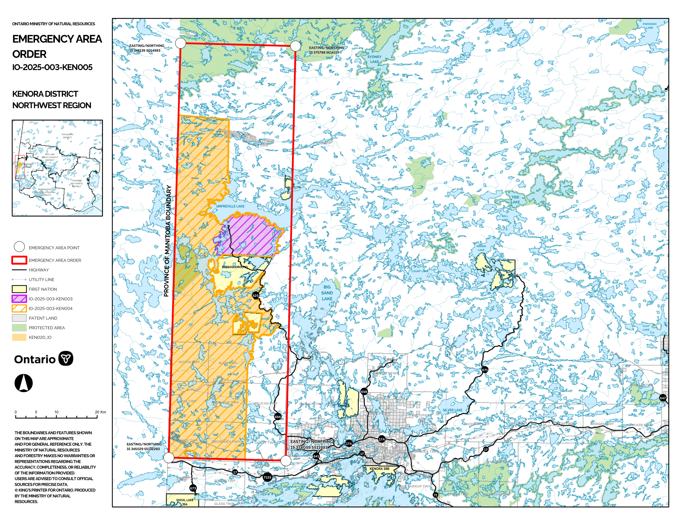
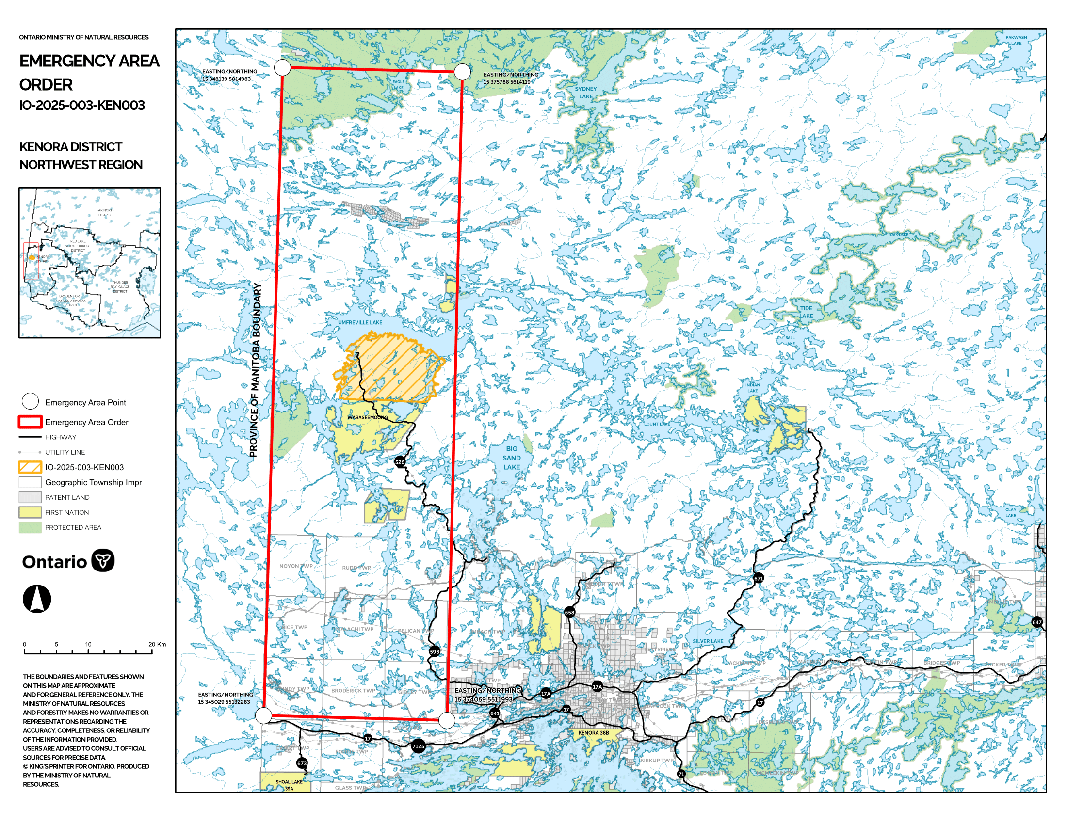
Fort Frances 4 – Fire Updates

Evacuation Alert

Following a recommendation from the Ministry of Natural Resources’ Fort Frances District, an evacuation alert is in place due to the evolving situation and increased fire behaviour of FOR004, residents and cottagers in the proximity of the fire are strongly encouraged to prepare to evacuate on short notice.

This includes all areas accessed by Camp 111 Road and Crooked Pine Road (Blalock Road). Nydia Lake, Eva Lake, Kawene Lake, Marion Lake, Marion Lake Road, Crystal Lake, all roads accessing Crystal lake, Niobe Lake, Nickleby Lake Road and Nickleby Lake, Sapawe Lake, Sapawe Mill, Sapawe Road, Sapawe/Upsala Road, Premier Lake Road, Marmion Lake – Reserve Island, Marmion Lake – Hoist Camp Narrows, Marmion Lake – Reserve Bay, Osinawi Lake, Pipeline Road, Sawbill Road, Cloven Road, Pinecone Road, Caldwell Road and Hardtack Road.

Please plan ahead and stay connected:

  • Make sure you are aware of the current fire situation
  • Prepare an emergency bag with your essentials (medicine, passports, legal documents etc.)
  • Monitor official channels for updates at ontario.ca/fireupdates
  • Be ready to quickly leave if instructed
  • Respect evacuation orders, road closures and public officials direction
  • Give crews and aircraft ample space to work
  • Forest, wildland and outdoor fires
  • Learn about forest and wildland fire activity, restrictions, management, safety and prevention.

Fort Frances 4 (FOR004) is now measuring approximately 2500 hectares in size. Heavy smoke from fires in the area has limited the ability of air attack. FireRanger crews are actioning the south end of fire while focusing on values protection in the north.